M2Prime - VMS
Solution for Monitoring & Tracking Vessels Position
M2Prime is a product part of AISSAT Prime, a vessel monitoring system. AISSAT M2Prime would help you provide the solution with parameters information just like what presented on the dashboard.
Advantages
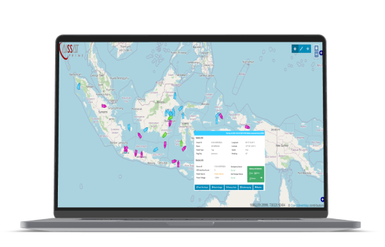
User Friendly Interface
Use the application easily without learn specific knowledge with user-friendly web-based map view
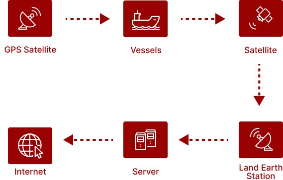
Unlimited Monitoring
World-wide range covered area monitoring, giving client no area limitation to monitor client own vessels around the world.
Monitor All Parameters
Monitor the position of the vessel and simultaneously the parameters on its dashboard
Key Features
- Highly user-friendly web-based map view
- World-wide range covered area monitoring
- Tracking vessel feature
- Statistic data reporting feature
- Client customized data monitoring system
- Export record data into CSV format
- Geo fence and alert features
Software Specification
Web Based Software
- Globally Accessible
- User Access Control (Admin, Operator)
- Redundancy Reliable Servers
- Linux Based Server
- Full Security Server
Map Tracking Function
- Zoom In & Zoom Out
- Vessel location & Tracking
- Playback of Previous Vessel Position
- Support Offline Tracking in Google Earth
- View Raw Data Tracking
Data Processing
- Alert Display
- Geo-fence Area Configuration
Document Export
- Export to excel or CSV document
- Auto Transmission Report: Email, SMS, FTP
- XML-Web-API (Application to Application)
We Developed The Hardware Ourselves
Hardware Specification
Core Module: M2Prime Module
- 5 Analog Input (DC Current 4-20 MA)
- 5 Analog Input (AC Current)
- 5 Analog Input (AC/DC Voltage up to 24V)
- 16 Digital Input
- 6 digital interrupt
- Up to 20 Relay output (Customize)
- SD Card 8 GB for up to 1 Year RPM Log data
- Wide Range Supply Input power 9–32 Volt
- RS-232
- RS-485 (Modbus)
Enclosure/Panel
- ATEX/Marine Standard
- IP-66 Standard (Dust Proof, Water Proof)
- Door Sensor/Tamper sensor
- Magnetic Sensor
- Battery
Satellite Modem
- Compatible with Multi Platform Satellite
- Compatible with Multi mode modem (GPRS, HSPA, Satellite)
How It Works?
- Tracking Monitoring system which made reference to applicable standard (IMO; Solas Chapter V Reg 19.1 LRIT, Etc).
- Data Tracking is sent real-time using satellite with worldwide coverage.
- Monitoring parameters are vessel identify, time stamp, position, speed, course/heading, distance.
- Alarm inside/outside geofencing area implementation.
- No blank spot in anytime and anywhere.


